Sunday, August 28, 2016

Skyline Divide to Chowder Ridge Anniversary Hike

Our last outing of our Anniversary week adventures wrapped up with a hike to Skyline Divide and continuing on towards Chowder Ridge. I haven't gone any farther than a small knoll to the right of the first ridge on the divide, so I was very excited to see just how far we would get.
We hiked the 2 miles up the divide trail before turning right and going over the first 2 (of 6) knolls. When we got to the 3rd knoll there was a fork in the trail again we took a right and headed south towards Chowder ridge. 
heading up the knolls
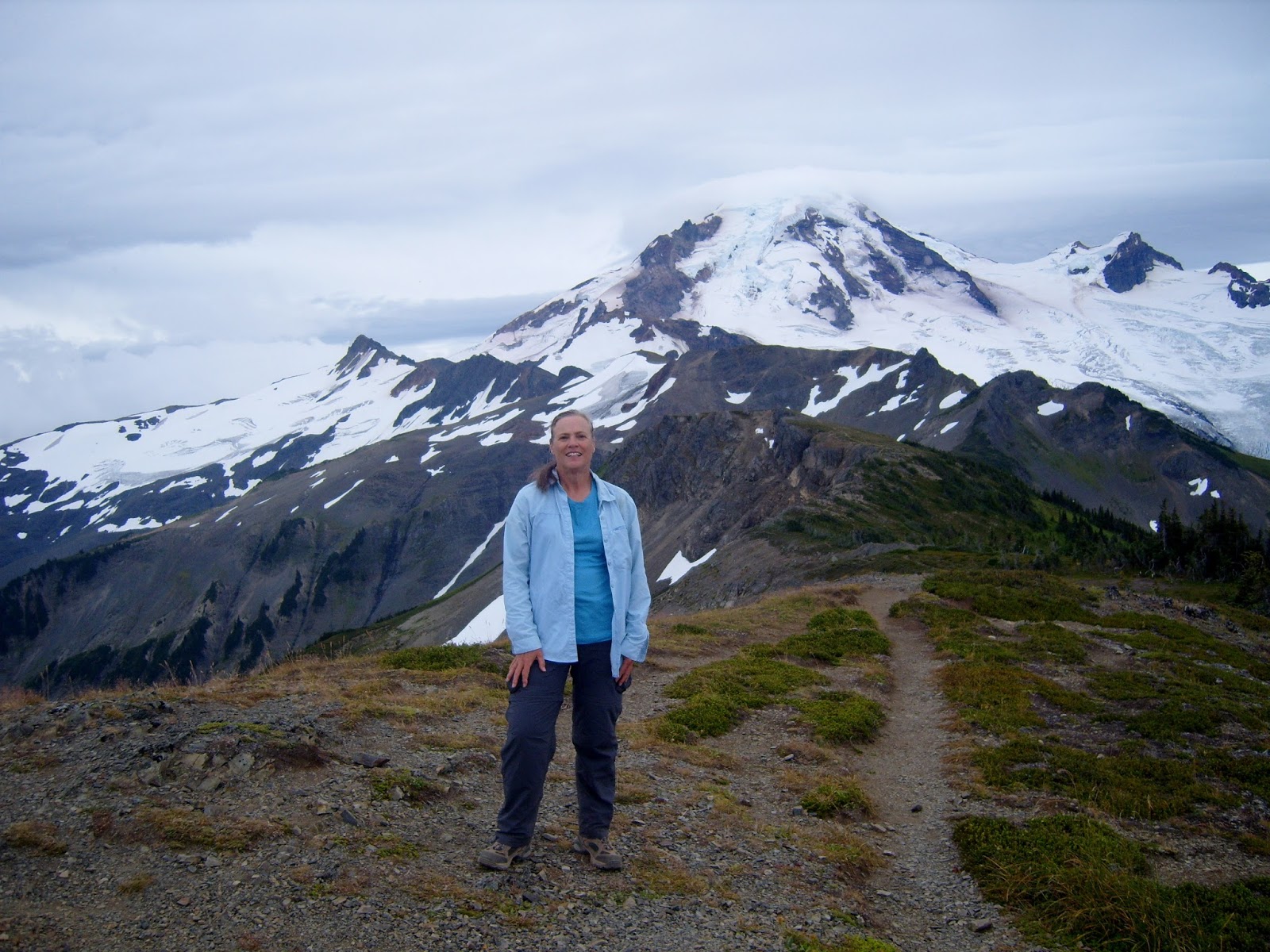
Skyline Divide behind me
Looking towards Skyline Divide from the knoll

Mt. Baker in the distance

In the photo below you can see the fork in the trail, the trail to the left goes towards Deadhorse creek. The trail to the right goes over another knoll and towards Chowder Ridge. We took the trail to the right.

In the distance you can see the 6th knoll. That is where we ate lunch. The views were incredible.

Pictures of "us" from the top of the knoll, looking towards Mt. Baker.


The photo below shows just how far we had come. Skyline Divide is the farthest green ridge on the left.

Panoramas of Shuksan and Mt. Baker.


As we headed back towards the Divide the clouds got darker and a few rain drops turned into a rain storm. We had packed our rain gear so we put it on and enjoyed our hike out.

This week of our 45th Anniversary set aside to backpack and hike together got me to thinking about how hiking and marriage are so similar:
you have to be committed to your goal to be successful
there are ups and downs
extremely low points
extremely high points
mountain top experiences
grit your teeth and just get through it experiences
sunshine and rainbows

As we were looking at Skyline Divide today and all of the valleys in between the ridges I realized marriages are like this. People grow apart and soon there is a divide so large it seems impossible to come together or the opposite can happen,  the two can grow closer through the years and build a stronger bond year by year.

In my adult years I've struggled to believe in God, I was raised in a Christian home but I have difficulty with alot of the concepts of organized religion and how they frame who and how God is.
I heard this parable alot in church as I was growing up "Train up a child in the way he should go: and when he is old, he will not depart from it" Proverbs 22:6 (KJV).
I may not have come completely back to my roots but there are some concepts that have stayed with me all of my life. I believe in love, hope and forgiveness. These concepts I learned as a child and have continued in my mind and heart as an adult. These are the foundations of my love in my marriage to my husband.

To us, "Happy 45th" may the highs always overshadow the lows.

Endomondo stats:
total miles hiked - 8.7 miles
minimum altitude - 4491 feet
maximum altitude - 6727 feet
 total ascent - 2999 feet
total descent - 3077 feet

If you'd like to read about our Anniversary week backpacking trip to Watson Lakes you can read it HERE, and our hike to Ptarmigan Ridge & the Portals HERE.

Friday, August 26, 2016

Ptarmigan Ridge and the Portals

Would this be the year that I actually make it all the way to the Portals? After our backpacking trip this week we decided to do a good, long day hike today. We had tried to get to the Portals last year and nearly made it, but turned around just short of going up the last stretch. You can read about that trip HERE.
We got an early start today, leaving our house at 7:30 this morning. We left the parking lot for the trail by 9am. It was a beautiful, clear sky day for hiking.

The wildflowers were still plentiful.


We were surprised by how many snow fields we had to cross today. The snow was soft and the footing was good, so no issues crossing them.

We saw many goats today, 9 along the trail towards the Chain lakes/Ptarmigan ridge junction. Then we saw around 30 near the little lake along the Ptarmigan ridge trail.

The photo below shows our destination. The Portals are on the right below Mt. Baker.

A closer photo of the Portals. We would be hiking to the left one. Right to the end,

but first another snow field crossing.

and about a 1/2 mile up to the top.

Walking along the spine of the Portal trail.

Mt. Baker

Looking at the Portals.

Our proud moments on the top.


At the Portal


A perfect day, I will always remember.

Endomondo stats:
total miles hiked - 12 miles
minimum altitude - 5006 feet
maximum altitude - 6472 feet
total ascent - 2503 feet
 total descent - 2694 feet

Watson lakes backpack trip

Tuesday morning we drove to Watson Lakes to begin a 3 day - 2 night backpacking trip. It's about a 10 1/2 miles drive from the Baker lake dam. The gravel road climbs all the way to the trail head with magnificent views of Mt. Baker along the way.
We arrived and as we began to take our packs out of the Van I noticed our front right tire was flat. :-(
So a quick tire change before we could head out on the trail.


Ready! 
I had weighed my pack before we left and it was 40 lbs. (I don't know how much my husband's weighed, but it was much heavier than mine.) A good amount for our first "mountain" trail backpacking trip in many years.

I've been to Watson lake only once before with the Trailblazer group that I hike with. You can read about that days hike HERE.
I "love" boardwalk trails and this trail doesn't disappoint. There are several sections with them.


The first of the two lakes in the photo below. It's about a two mile hike into the first lake and another 1/2 mile to the second one. We planned on camping at the second one. 

The second lake in the photo below. When I had hiked there with the Senior Trailblazers last year I had spied a campsite that I really thought we would enjoy if we ever went camping there. I was anxious to see if it was available.

I was so pleased that it was available. We set up our tent and made our camp cozy.

Then it was time for a swim!

The first night we enjoyed a small sunset in "our" lake.

The heart rock in the photo below was in the ground at our campsite. An omen, perhaps. This is our 45th wedding anniversary week. We had a plan to backpack and hike for the week. Just doing things we enjoy together. If you look at the way the dirt was deposited in the heart stone you can see that there is a tent in the indention. <3

My perch for reading, drawing and doing Sudoku in our downtime.

The second day we did a day hike to Anderson Lake. We passed the trail junction on our way to Watson lakes. It was a short hike from the junction marker. It only took us about 15 minutes to get down to the Lake and meadow.

Anderson Lake

A great view of Mt. Baker from the meadow.

We walked around the meadow area a bit exploring before stopping at the lake for lunch.


 When we got back to our campsite for dinner, I noticed that the ridge to the right of us had a face in it, do you see it?

Spartan training never ends, yes I got my 100 push ups in while we were there.

I never tired of our view from our tent door.

Thursday morning, time to go. 
It was a wonderful time for us at this alpine lake in the Pacific Northwest.

On our way out, a view of  both lakes and me ;-)

Walking through the forest, savoring every moment.

Did I mention the stars at night.....? 
Simply Amazing!

Endomondo stats: 
Tuesday, into the second Watson lake
total miles - 2.7 miles
minimum altitude - 4314 feet
maximum altitude - 4847 feet
total ascent - 814 feet
total descent - 705 feet

Wednesday, Anderson lake day hike
total miles - 4.42 miles
minimum altitude - 4281 miles
maximum altitude - 4691 feet
total ascent -1024 feet
 total descent - 1450 feet

Thursday, to the car from Watson lake
total miles - 2.8 miles
minimum altitude 4343 feet
maximum altitude - 4861 feet
total ascent - 692 feet
total descent - 784 feet

*Yes, we went to Les Schwabs in Sedro Woolley and bought new tires all the way around and a new full size spare.