

Saturday, May 27, 2017
Friday, May 26, 2017
Noisy Creek hike
Thursday was a long day in the car and on the trail, so I'm writing my post about it this morning.
My husband and I agreed that Noisy Creek would be our hiking destination. After a long car ride from Everson we drove to Baker lake to begin our hike. We started hiking at 12:30 and didn't get home until 9pm last night.
It was a wonderful day for our hike. I decided that the Noisy Creek trail should be put on a list entitled "The Best PNW trails to hike on a hot day". The trail has very few sections where you are in full sun. The shade and mist in the air near the falls and creeks would be the perfect escape on a hot summer day.
It was warm enough yesterday that the shade and cool air around the falls and creeks was refreshing.
I only have one gripe to the forest service. There really isn't any trail info, at the parking lot. It would be nice if they would post a list of trails the are available from the parking lot, with a map as well on the signboard. There really was no trail info, at the parking lot. There was a woman at the lot asking around if this was the Noisy creek trailhead parking lot. Too bad, it's a Loooong way to drive to be unsure of where you're hiking. I know that the info. can be found online and in books, but a trailhead sign would be wonderful.
The first 1/2 mile is a nice wide corridor through the forest. I always laugh to myself because it's easy to tell on a trail where the majority of people stop hiking and turn around. The trail becomes noticeably more narrow where the "destination" hikers continue on. On this trail it seemed to be at about the first very large Cedar tree.

It's really too bad that most seem to turn around there, since just a few yards farther they would have come to this:
The Baker River suspension bridge

Baker River

We went across the Suspension bridge for our hike to Noisy Creek. You can hike to Sulphide Creek for a shorter hike and a nice location for lunch by going straight on the trail before crossing the bridge. I hiked there once with the Senior Trailblazers from Bellingham in May of 2011, you can read about that trip and see photos of Sulphide Creek in my blog post HERE.
After we had hiked for about 2 miles we came to Hidden Creek. A large tree had fallen at the bridge and had damaged just the first section, but they had cleared it. We talked to a trail crew person about their efforts in repairing the bridge. They are using Cedar from the area and hand cutting the boards that they will place on the bridge. The air was full of the scent of cut Cedar. Heavenly!
There are caution tapes blocking the approach at both ends of the bridge. The crew person stressed that if we were to cross - it would be at our own risk. We accepted the terms. The damaged end had some temporary planks situated as a foot bridge to the main span. So we went on ahead and crossed.
The first time I stepped across this bridge was 6 years ago.
Here's me - then and now on the Hidden Creek bridge.

The trail then continues through the beautiful forest, with a few creek crossings with and without (2 or 3) bridges and some boardwalks on the trail.

We planned on eating at the Noisy Creek campground, but decided to first walk out to the Noisy Creek bridge.
What a view we had of Mt. Baker as we were walking to Noisy Creek.

Noisy Creek

Looking at Baker Lake from the Noisy Creek bridge.

Time for a late lunch at the campground,


As we were walking back on the trail about half way from the campground and the Hidden Creek bridge we heard a massive explosion. Our minds raced from a huge tree falling, to a creek/rock burst to a plane crash. We never did see any evidence of anything on the trail, but it kept us wondering as to just what had happened.
I didn't get any pictures of them but the trail (mostly in the moist creek areas) was jumping ;-) with tiny brown frogs.
Another of the "no bridge" creek crossings.

This trail has so many hidden gems along it.
Garmin stats:
total miles hiked - 10.5
minimum altitude - 1003 feet
maximum altitude - 1195 feet
total ascent - 1217
total descent - 1391 feet
My husband and I agreed that Noisy Creek would be our hiking destination. After a long car ride from Everson we drove to Baker lake to begin our hike. We started hiking at 12:30 and didn't get home until 9pm last night.
It was a wonderful day for our hike. I decided that the Noisy Creek trail should be put on a list entitled "The Best PNW trails to hike on a hot day". The trail has very few sections where you are in full sun. The shade and mist in the air near the falls and creeks would be the perfect escape on a hot summer day.
It was warm enough yesterday that the shade and cool air around the falls and creeks was refreshing.
I only have one gripe to the forest service. There really isn't any trail info, at the parking lot. It would be nice if they would post a list of trails the are available from the parking lot, with a map as well on the signboard. There really was no trail info, at the parking lot. There was a woman at the lot asking around if this was the Noisy creek trailhead parking lot. Too bad, it's a Loooong way to drive to be unsure of where you're hiking. I know that the info. can be found online and in books, but a trailhead sign would be wonderful.
The first 1/2 mile is a nice wide corridor through the forest. I always laugh to myself because it's easy to tell on a trail where the majority of people stop hiking and turn around. The trail becomes noticeably more narrow where the "destination" hikers continue on. On this trail it seemed to be at about the first very large Cedar tree.

It's really too bad that most seem to turn around there, since just a few yards farther they would have come to this:
The Baker River suspension bridge

Baker River

We went across the Suspension bridge for our hike to Noisy Creek. You can hike to Sulphide Creek for a shorter hike and a nice location for lunch by going straight on the trail before crossing the bridge. I hiked there once with the Senior Trailblazers from Bellingham in May of 2011, you can read about that trip and see photos of Sulphide Creek in my blog post HERE.
After we had hiked for about 2 miles we came to Hidden Creek. A large tree had fallen at the bridge and had damaged just the first section, but they had cleared it. We talked to a trail crew person about their efforts in repairing the bridge. They are using Cedar from the area and hand cutting the boards that they will place on the bridge. The air was full of the scent of cut Cedar. Heavenly!
There are caution tapes blocking the approach at both ends of the bridge. The crew person stressed that if we were to cross - it would be at our own risk. We accepted the terms. The damaged end had some temporary planks situated as a foot bridge to the main span. So we went on ahead and crossed.
The first time I stepped across this bridge was 6 years ago.
Here's me - then and now on the Hidden Creek bridge.

The trail then continues through the beautiful forest, with a few creek crossings with and without (2 or 3) bridges and some boardwalks on the trail.
 |
| one of the "no bridge" creek crossings |
 |
| boardwalk |
 |
| bleeding hearts |
 |
| bunch berries |

We planned on eating at the Noisy Creek campground, but decided to first walk out to the Noisy Creek bridge.
What a view we had of Mt. Baker as we were walking to Noisy Creek.

Noisy Creek

Looking at Baker Lake from the Noisy Creek bridge.

Time for a late lunch at the campground,


As we were walking back on the trail about half way from the campground and the Hidden Creek bridge we heard a massive explosion. Our minds raced from a huge tree falling, to a creek/rock burst to a plane crash. We never did see any evidence of anything on the trail, but it kept us wondering as to just what had happened.
I didn't get any pictures of them but the trail (mostly in the moist creek areas) was jumping ;-) with tiny brown frogs.
Another of the "no bridge" creek crossings.

This trail has so many hidden gems along it.
Garmin stats:
total miles hiked - 10.5
minimum altitude - 1003 feet
maximum altitude - 1195 feet
total ascent - 1217
total descent - 1391 feet
Sunday, May 21, 2017
Artist point Snowshoe
Blue skies, be still my beating heart.
Into the mountains we must go 😎.
We decided we were due for a nice day of snowshoeing. We got our gear and lunch together and drove to the ski area parking lot. The gate is locked and the road IS NOT plowed. This is what the gate/road entrance looked like on Mother's day, just one week ago.

As we were driving up near the Excelsior trail head area of the Mt. Baker hwy, the car in front of us put on his brakes and swerved. There was a black bear running across the road. The bear didn't waste anytime getting off of the road. He quickly ran into the forest safe and sound.
Ready to play!

As were we hiking up we saw a group of skiers/boarders using a homemade rope tow. It was fun watching them go up and down. It was a long run and fairly steep, definitely not for the faint of heart.
In the photo below, a boarder is getting set up for the tow up.

Beginning his ascent.

I video'd the ascent and the descent. You can watch them here.
Ascent: https://youtu.be/68iqp0WZiA8
Descent, with a nice jump:
The views on our hike were fantastic.
In the photo below you can see Table mountain and Herman Saddle.

My husband working his way up the hill, we didn't follow the road, because we didn't want to and besides it was nowhere to be seen. We did follow an old groomed ski trail for awhile though.

Shuksan

Continuing our way up.

We eventually broke away from the groomed trails and headed up our own route.

We ate our lunch at this great spot, you can see Mount Baker behind me in the distance.

Not long after I took the photo below, a group of climbers hiked to the tree area just below Table mountain. They are going to be climbing Rainier soon and were going to use the weekend for training. They set up a snow camp near the trees at the base of Table mountain. We enjoyed watching their efforts while we ate our lunch.

Artist point is visible at the right of Mount Baker, in the photo below.

Can you tell that this is the Artist Point parking lot. Lots of snow up there yet. We couldn't even find where the bathroom was. The roof isn't peeking out at all.

Someone's tracks heading up towards Table mountain.

My husband enjoying the view of Shuksan.

If you look waaaay down the hill, you can see where we began.
The ski lodge and parking area are down there.
The ski lodge and parking area are down there.

As the temperatures kept climbing throughout the day, the snow got softer and softer. This is what we found as we drove down the hill.

Our day in the snow couldn't have been better.
Garmin stats:
total miles - 3.65 miles
minimum altitude - 4369 feet
maximum altitude - 5209 feet
total ascent - 823 feet
total descent - 909 feet
Garmin stats:
total miles - 3.65 miles
minimum altitude - 4369 feet
maximum altitude - 5209 feet
total ascent - 823 feet
total descent - 909 feet
Friday, May 19, 2017

Saturday, May 13, 2017
Montana Beast/Sprint 2017 results
Home from the Big Sky state. I love our trips to Montana. We camped our way to Big Fork. The first night out was at Lincoln Rock state park in eastern Washington. We car camped (slept in our Van) and used a large pop up tent for our belongings and to have a space to be in if we had any rain.

Cute little Marmot's here and there in the rocks.

Lake Entiat


Our first "bear" sighting at the RV park!


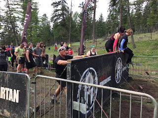
In the start chute photo below you can see the 5 foot wall that has to be scaled before crossing the start line. They ran waves of people through every 15 minutes.


About 7 miles of the Beast course was a large loop. Here's a couple of Spartan official photos of obstacles he did out on the loop.
I didn't see him until he came down towards the barbwire crawl. Nice to see his smiling face again.

Before the barbwire, they had a high hurdle for everyone to get over.


The long barbwire that we had the last two years was broken up by the placement of the Slip wall halfway through.

In the photo below, you can now see the rest of the barbwire crawl - after the slip wall.


My husband is patiently watching my journey down the hill.


Spartan sprint finishers.


Cute little Marmot's here and there in the rocks.

Lake Entiat

We traveled through I-90 to St. Regis Montana. We stayed at the Nugget RV park for the night. It's a wonderful campground. I highly recommend it.

Our first "bear" sighting at the RV park!

It's always exciting when we see Flathead lake for the first time. The Spartan race day excitement/nerves really begin to kick in.
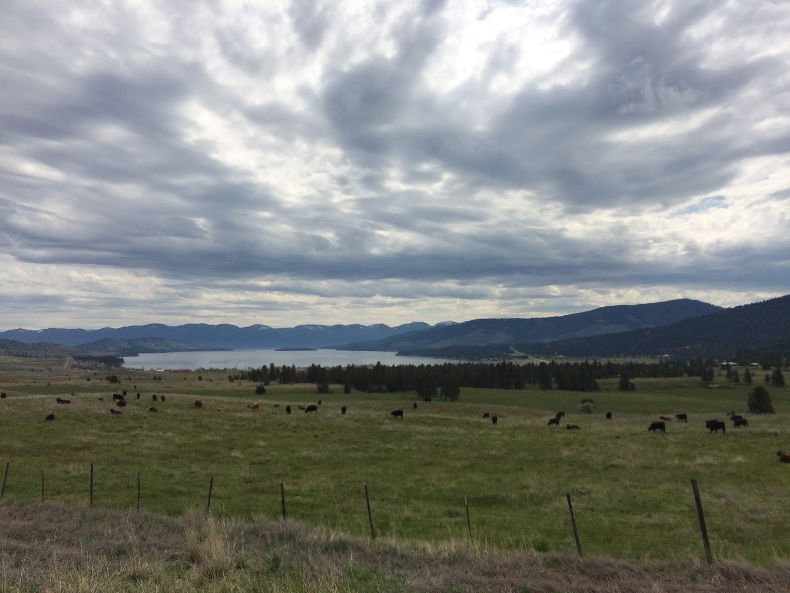
We have stayed at the Outback RV park for 3 years in a row. Last year we reserved our campsite for this years race within a few weeks of being there to ensure staying at the same site.
It remembered us ❤.

This year my husband did the Beast alone. Thankfully he had the best weather of the weekend for his race. Just a few sprinkles in the afternoon. Lucky for the Beast racers.
Their day was about 12 1/2 miles with 36 obstacles. He missed 3 obstacle so he did 90 penalty burpees plus 5 mandatory obstacle burpees.


In the start chute photo below you can see the 5 foot wall that has to be scaled before crossing the start line. They ran waves of people through every 15 minutes.


About 7 miles of the Beast course was a large loop. Here's a couple of Spartan official photos of obstacles he did out on the loop.
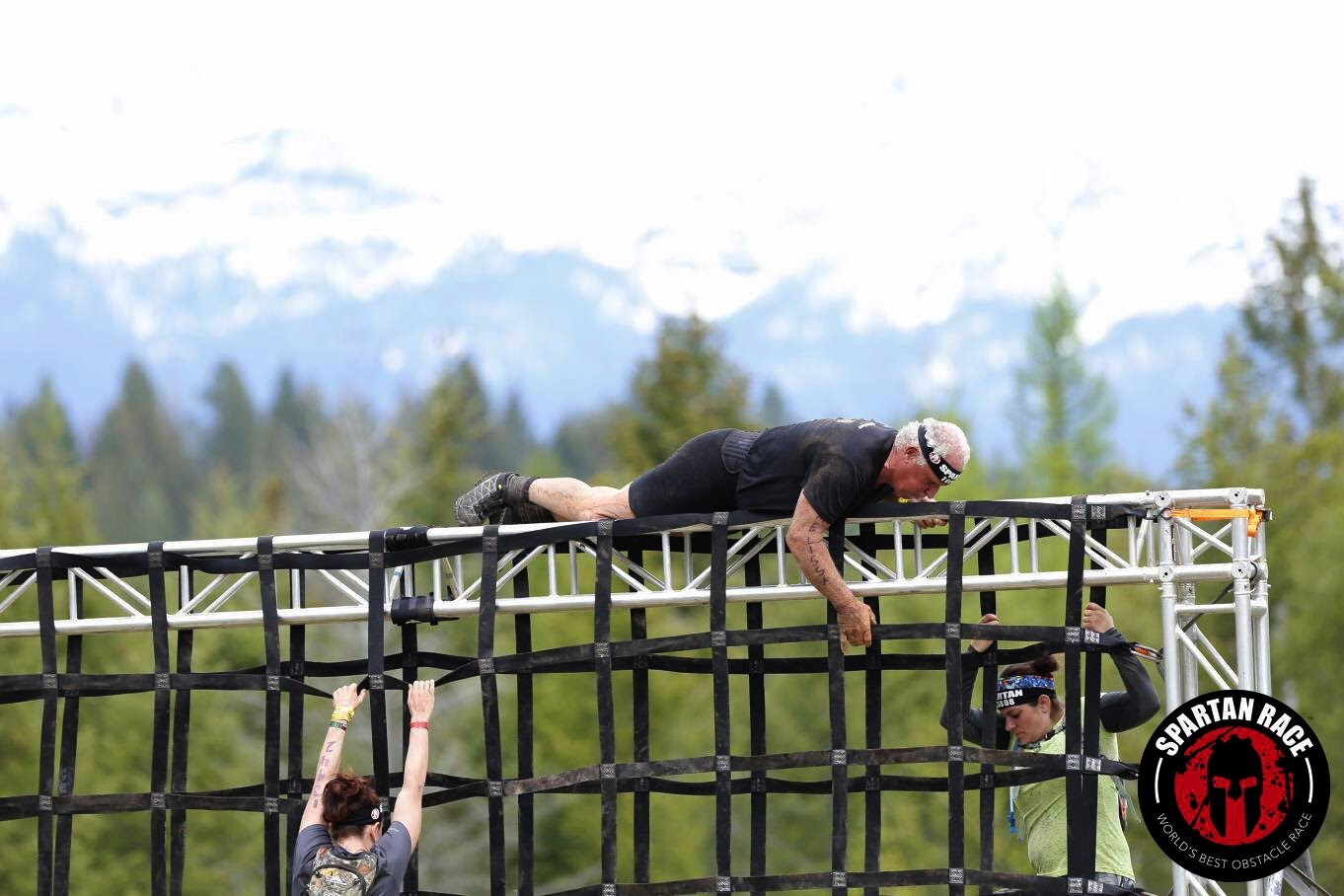 |
| Vertical cargo net |
 |
| Log Carry |
I didn't see him until he came down towards the barbwire crawl. Nice to see his smiling face again.

Before the barbwire, they had a high hurdle for everyone to get over.


The long barbwire that we had the last two years was broken up by the placement of the Slip wall halfway through.

In the photo below, you can now see the rest of the barbwire crawl - after the slip wall.

Burpee time for not completing the "Twista" obstacle. It looks like the monkey bars except each hand grip is individual and turns when you grasp it.

Here's a little video of him doing his burpees ;-) with the festival music playing in the background.
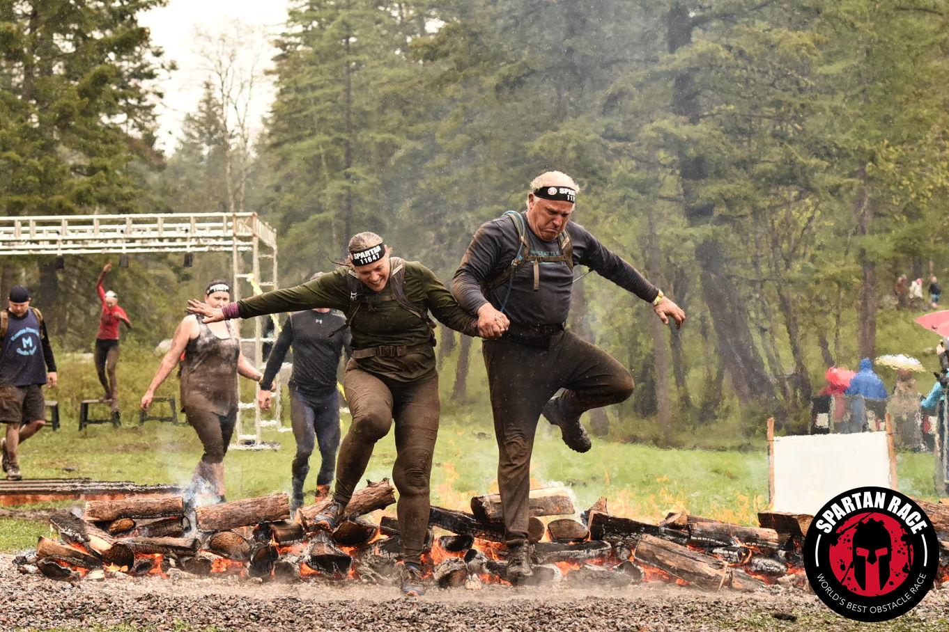
I'm glad I was there to take some pictures, because I couldn't find an official fire jump photo in the Spartan race event photo album.


First Trifecta!!
3 wedges complete.

Day 2 for my husband. He did my Sprint with me. We woke up Sunday for the Sprint to a cold rainy morning. My weather station said 43 degrees when we started for the race. We tried something different this year. In the past we got car rides from the RV hosts to the race start, but this year we drove to the bus shuttle area just to experience it. Here I am ready as I'll ever be.

Being Washingtonians we came with an umbrella, it really helped. We at least got to stay dry until we checked our bags before the start. In the photo below, my husband was giving me tips about what I'd encounter on the course as part of his Beast course followed our Sprint course. I really appreciated his insight for what was ahead of me that day.

We had very few official Spartan photos for the Sprint, I think the photographers had difficulty keeping their cameras dry.


I had thought to put a Tyvek jacket in my camelbak pack, and boy did it come in handy. Tyvek jackets are nice because they don't weigh anything. When we got to the A frame cargo net at the top of the hill, we were backed up and my husband counted out 26 of us on one side at the same time. I'd never been on it with that many people at a time. Because of the weather the webbing straps were stretched out and saggy. It was swaying slightly from the weight of everyone on it. The volunteer official had to keep reminding us to wait near the top & leave some space in front of us so the person in front of us could swing their leg over the top without kicking us in the head. It had happened to a few people that day. Anyway, I was so proud of my husband while we were on that obstacle. He helped talk a women through the climb. He did a great job of calming her so she could overcome her fear of heights. Since we had to wait and go very slowly over that obstacle, I got so cold that I was shaking. I put on my paperweight jacket. I was so glad I thought to bring it.
They did manage to get some photos of our bucket carry, but we are blurry :-(.
I'm wearing my white tyvek jacket in the photo. I found it easier to walk sideways down the hill. I couldn't see over the bucket to see where to put my feet.

My husband is patiently watching my journey down the hill.

Our fire jump pictures.
I was sooo happy to see that finish line.

Spartan sprint finishers.

Thinking back to 3 years ago and my first Spartan race to yesterday, what a difference. I'm proud of these bruises. It took 3 years but I've learned how to get up and over that slip wall by myself.
Life can seem impassable at times but as I've learned in these events, put one foot in front of the other and I will get through the obstacle and someday conquer it and find peace.
*Another lesson learned at these events, be grateful for that helping hand up. It may be the only way through the obstacle.
The same with life.
 |
| Breakfast at the Woods Bay Grill the next morning. |
"Success in never final, failure is never fatal. It's courage that counts." John Wooden
Garmin stats:
total miles - 6.06 miles
minimum altitude - 3110 feet
maximum feet - 3833 feet
total ascent - 1503 feet
total descent - 1532 feet
I did 85 burpees, my husband shared doing burpees with me. He did 35 of mine. 120 total for the day.
Happy to be home from Montana my place of big skies and big dreams.

Subscribe to:
Posts (Atom)