 |
| Click HERE to read about the Tower of Power. |
Friday, July 29, 2016
Sunday, July 24, 2016
South Fork, Ridley Creek hikes
For our Spartan weekend training we decided to do 2 back to back hikes to help us with our endurance. We chose to do the South Fork trail again but go for the creek crossing and see how far we wanted to go. We did part of this hike previously on the 4th of July, you can see more photos and read more about that day's hike HERE. We were pleasantly surprised to find some back country horsemen doing trail work on the trail and they told us about a trail that forks off to the left after the creek crossing that leads up a hill & has a picnic table at the top. So inspired, we took off in search of new adventures. They were right we found the trail and the picnic table, we hiked on a bit more and then returned for lunch at the table before heading back.
Our total for Saturday's hike:
total miles hiked - 10
minimum altitude - 418 feet
maximum altitude - 1255 feet
total ascent - 1155 feet
total descent - 1109 feet
Today (Sunday) we chose to do the Ridley creek hike that I had done a couple of weeks ago with the Trailblazers, you can read about that day's hike HERE. On the Trailblazer hike we turned around at the first boggy tarn area about 1/2 mile short of the Mazama horse camp meadow. I was excited to get further up today as this would be the first time we'd been at the horse camp in 25 years!
A side note about my garmin watch. I had it set for "smart" gps tracking for the Trailblazer hike and it skipped some of the downhill switchbacks so the mileage wasn't the same on our return hike back as it was going in. The "smart" tracking is supposed to save battery life but only tracks every minute, which I found to not be great if walking quickly down switchbacks. This time I switched my tracking to every second and the distance was the same going as coming. Yay! I was much happier with the gps tracking on today's hike.
We did make it to the meadow and it was spectacular. We stayed for nearly an hour and enjoyed a leisurely lunch before heading back. A great weekend of back to back hikes!
total stats for Sunday's hike:
total miles hiked - 9
minimum altitude - 2571 feet
maximum altitude - 4343
total ascent - 2359 feet
total descent - 2316 feet
Total for the weekend:
19 miles hiked
2 weeks till the Portland Sprint, I think I'm about ready!
| AROO! |
Friday, July 22, 2016
Tuesday, July 19, 2016
Interurban trail running - Spartan training
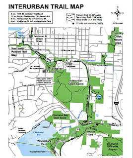
This past weeks Sunday "together" training run with my husband didn't happen since we weren't together for the weekend. So I ran 10 miles by myself on Monday. I started at the Rotary Trail head. Our next Spartan race is the Portland Sprint August 6th (really in Washougal Washington).
From the trail head I followed the interurban trail to Old Samish hwy then turned & ran on the road to the North Chuckanut Mtn. trail head parking lot.
There is now a Sani Can (outhouse) at the North Chuckanut mtn. trail head parking lot. I then resumed my route on the interurban trail. I ran 5 miles before turning around shortly after entering the Larrabee state park boundary trail marker.
I didn't walk/run this today, I decided to try and run the whole way. I succeeded and didn't walk at all.
Yay me!
Not the hilly trails we've been working on together but I was more interested in just getting the distance in.
Endomondo stats:
total miles ran - 10 miles
minimum altitude - 61 feet
maximum altitude - 232 feet
total ascent - 476 feet
total descent - 486 feet
Friday, July 15, 2016
Thursday, July 14, 2016
Ridley Creek 2016 Trailblazer hike
Today's Senior Trailblazer hiking destination was Ridley Creek. Our group hiked this last year at about this same time you can read about that day's hike HERE.
12 of us drove in carpools to the Mt. Baker hwy, on to the Mosquito Lake road and then turned left on Forest Service road 38 and drove 13 miles to the trailhead.
After a map conference with our "fearless leader" Pat, we signed in and began our hike through the beautiful forest.
| note the glasses on the signpost ;-) |
The Deming glacier was visible as we were crossing the Middle fork of the Nooksack river.
Pat crossing the bridge.
Misc. forest views while we hiked.
The trail is quite steep in places and very muddy but really in pretty good condition.
There were many Columbine's in bloom.
We hiked about 4 miles to the first meadow opening and enjoyed the view of Park Butte before heading back down the trail. We did see the lookout on our way up, but it's not visible from this angle.
I took the photo below because the way the light was in this particular area made it appear as a painting to me. Sometimes when we hike I just have to take a moment and say "yes, this is why I hike".
We didn't make it the the "official" meadow, but we got closer than last year & that made me happy.
Endomondo stats;
total miles hiked - 8 miles
(Garmin info. from a fellow hiker, mine didn't do the return distance correctly.
minimum altitude - 2561 feet
maximum altitude - 4301 feet
total ascent - 2149 feet
total descent - 2123 feet
Monday, July 11, 2016
Chuckanut trail running - Spartan training
My husband and I have decided that we should be running longer distances and hills if we are to survive our upcoming Spartan races (Sprint & Beast). The Chuckanut Mtn.trail system provides just what we need: a huge network of trails with long ups and downs. So Sunday we parked at the North Chuckanut Mtn.trail head as we did for last week's first Spartan training weekend run. We agreed that each run from now on would be over 10 miles, since October's Beast will be 12 to 14 miles in distance. Our goal on these training days will be to run as much as possible, we now walk up quite a bit of the uphills but our goal is to be able to run up and down every hill by October.
This was our route:
Start - North Chuckanut Mtn. trail head
Arroyo Park trail
Hemlock trail
North Lost lake trail
South Lost lake trail
Fragrance lake loop trail
Chuckanut bay trail
Two dollar trail
Cleator rd.
Interurban trail
End - North Chuckanut Mtn. trail head
Here's some pics of the day -
Trails signs
Trails and road
Scenery ;-)
Lots of uphill and downhill, just what we wanted & bonus - beautiful forests and spectacular views.
Great training day.
Endomondo stats:
total miles ran - 12.65 miles
minimum altitude - 96 feet
maximum altitude - 1582 feet
minimum altitude - 96 feet
maximum altitude - 1582 feet
total ascent - 2080 feet
total descent - 2073 feet
Friday, July 8, 2016
Thursday, July 7, 2016
Sauk mtn. 2016 Trailblazer hike
I went on today's hike wondering just what we were going to get to see. The weather forecast called for clouds with increasing rain as the day progressed. The hike at Sauk mountain is all about the view and the wildflowers this time of year. I wasn't sure if we were early or late for the best viewing of the blooms. We had overcast skies when our group of 11 began hiking and just a few sprinkles of rain were falling, so we put on our rain gear and hoped for the best.
Someone put this boot on the trail sign. I wonder if someone changed shoes at their car after the hike and forgot one. oops!
The confluence of the Sauk and Skagit rivers.
The flowers were still in bloom!
I love this view looking back down towards the parking lot and the switchbacks below.
Pat "our fearless leader" and most of our group usually stop and eat lunch at the ridge before the top.
We had a short conference and three of us (Joe, Barb and myself) agreed that we'd like to go all the way up, so after clearing it with Pat we headed to the top for lunch. Barb took the photo below, it shows the few snow areas we needed to cross to get to the top. It wasn't slick at all and was an easy walk to get to the snow free areas.
Me at the top of Sauk mtn. (thanks Joe) As you can see the clouds had come in and there wasn't any view from the top,
except for our cute friend ;-)
As we were eating I was surprised to be told a marmot was near, so I sat still while he enjoyed our company!
The foggy return, all in all a great day to be socked in at the Sauk!
Endomondo totals:
total miles hiked - 4.2
minimum altitude - 4292 feet
maximum altitude - 5457 feet
total ascent - 1224 feet
total descent - 1253 feet
Tuesday, July 5, 2016
June Summary ~ Spartan Race(s) training
Junes's training stats for my upcoming Spartan races (August - Portland Sprint, October - Seattle Beast)
If you click on the photo below to enlarge it you will see that the activities are color coded for running, biking, hiking, walking, yoga and tai chi.
Subscribe to:
Posts (Atom)


