Thursday, March 30, 2017

Lummi Island walkabout

Today we weren't sure just what we were going to do. 
It's our usual hiking day, but we had some benefit changes to take care of at the local Social Security office. We arrived at the office just before it opened, we wanted to be first in line in case our waiting time took all day. Happily we were seen with only a half hour wait. We stopped at Woods and got some coffee to go and decided to go for a drive. We debated about heading home and getting our hiking things together or just hike tomorrow. As we were driving past Gooseberry point, I nonchalantly mentioned that it would be fun to take the ferry to Lummi Island as we hadn't been there for a long time. My husband surprised me and said "yes". It was agreed, we would take the ferry as walk ons and then walk on the Island.
Crab pots near the ferry landing
We stopped at the store as soon as we were on the Island to buy water and some snacks for our walk. We bought an Island map for a dollar at the store, so we could make some decisions on directions as we went our way. We then headed out thinking our walk for the day might be between 5 and 7 miles. We walked along the road and noticed a sign that said Curry preserve. We checked it out and decided to walk the trails before we went around the Island. 
The skies got bluer and bluer as the day went on, just beautiful!

I'm so glad we checked it out, it's a wonderful area to explore.


We then went back to the road and began our loop tour of the Island. We stopped at Sunset beach for a break. It's been along time since we've had a warm sunny day, it was nice to just sit and enjoy the solar rays.
Looking toward Orcas Island
Back out to the road, we walked on to the Lummi church beach for another sun basking break.
I took a video of our view.
Enjoy!

As we continued walking on the road towards the ferry landing, we checked out the map and decided to take another loop at this part of the Island before we finished. We found another preserve, the Otto preserve and stopped in to chat with the staff at the center. We discovered that there is another preserve, the Baker preserve near this one and another preserve is being established beyond that one as well. We definitely will have to go back as all of these preserves have hiking trails to explore. More fun, for another trip!
All of our wanderings really added miles to our day. 
13 miles!

It wasn't a planned hike, but it couldn't have been better if we'd planned it.
We really enjoyed our walk about on Lummi Island today.

Garmin stats:
total miles walked - 13 miles
total ascent - 902 feet
total descent - 997 feet


Monday, March 27, 2017

Mon Oeuvre ~ Mics. projects: Hexagon Mug rug

"Oeuvre" (the works of a painter, composer, or author regarded collectively: "the complete oeuvre of Mozart" a work of art, music, or literature: "an early oeuvre" ORIGIN late 19th cent.: French, literally ‘work.’ - Oxford Dictionary.)

I thought I'd make a mug rug, so I looked on the Crafty site and found a cute Hexagon pattern. My daughter loves to exercise at Orange Theory gyms, so I made her an "Orange Theory" inspired orange hexagon mug rug. I'd never bound a hexagon shape before, it took a few tries but I think I figured it out. 

*note to self, buy orange thread.

Here it is, being useful in it's new home.


Saturday, March 25, 2017

Miller Peninsula hike

Today's hike finds me at the Olympic Peninsula. We are visiting family for a few days. My brother had a hike planned for today at Miller Peninsula State park, so I tagged along.

baby fern

rough skinned Newt


mini mushrooms

mini mushroom

Such a fun time in a new forest!

Garmin stats:
total miles hiked - 6.7 miles
minimum altitude - 275
maximum altitude - 480 feet
total ascent - 459
total descent - 902 feet


Friday, March 17, 2017

Picture of the week ~ Seeds of reflection

What seeds are you planting?
Seeds of love or seeds of hate? 
Your life your choice.
Japanese lantern seed pod, with an Apple tree reflection in our pond.


Thursday, March 16, 2017

Blanchard Mountain wander

We had a fun day roaming the trails of  Blanchard mountain today. 
We chose to start from the Samish Overlook parking lot. It has a wonderful view of Skagit county and it is a hang glider launch site.

 The trail crosses a couple of creeks as it winds it way up. I took a video of the first creek crossing. You can watch it here - https://youtu.be/fh77ujRVzHI.


It was very cold when we took a break at Oyster Dome. There was a bitter wind when we stopped at the top. A little overcast for our view, but still nice.

We then headed towards Lily lake.

A bit of snow on the trail.

Lily lake.

Up to North Butte for lunch.

I have an app on my phone that add the gps info. to the photo taken. If you enlarge it you'll see the coordinates, the elevation - in meters and feet and the date and time the photo was taken.
  Kindof fun!

It wasn't as cold on the North Butte as we were protected from the wind a bit better that at Oyster Dome. So we enjoyed a more leisurely food stop there.
On our way down to Lizard Lake we ran into snow again. I brought my Yaktraks but didn't need to use them. The footing was fine.

Lizard Lake still frozen.

After taking some time to enjoy looking at the frozen lake and the many trees chewed on by Beavers we made our way back to the trail and headed towards Lily lake again.

We didn't go quit as far as Lily lake, but headed out on Max's shortcut. 
I love this trail.

The sun decided to play hide and seek while we were on Max's shortcut trail. I tried to capture how it made the forest look. This was the best I got.

Max's shortcut connects to the Larry Reed trail, just a couple of more miles and we'd be back at the Samish Overlook. For some reason, I guess it's my age and the generation I grew up in. I always call this trail the Larry Bird trail. Oops.

Garmin stats:
Total miles hiked - 8.6 miles
 minimum atltitude - 1079 feet
maximum altitude - 2237 feet
total ascent - 1847 feet
total descent - 2149 feet


Monday, March 13, 2017

Mon Oeuvre ~ en provence Mystery Quilt progress 14: COMPLETE!

"Oeuvre" (the works of a painter, composer, or author regarded collectively: "the complete oeuvre of Mozart" a work of art, music, or literature: "an early oeuvre" ORIGIN late 19th cent.: French, literally ‘work.’ - Oxford Dictionary.)

My "en Provence" mystery Quilt is now completed! 
I began this quilt with clues presented to us each Friday AM from Bonnie Hunter (Quiltville). Bonnie Hunter graciously offers a free mystery quilt every year in November. It lasts till February, after the last clue is presented she takes all of the clues away and makes the pattern available for purchase. So if we haven't printed our clues out every week, the only way to catch up is to buy the pattern. I first began posting my progress with THIS post from December 5, 2016.

Here is my finished quilt -

Here's the official graphic for the en provence Mystery quilt.


Sunday, March 12, 2017

Heart/Erie lakes trail run

We enjoyed our hikes in the Anacortes area Thursday so much that we decided to go back to Heart lake & run there today for our Spartan race training run. You can read about our Thursday hikes at Sharpe park, Heart & Erie lakes HERE. 
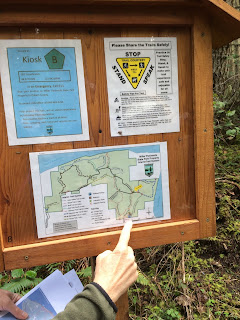
We started at the Heart lake parking lot and ran to Erie lake and back. I took this map photo at a kiosk just down the trail from where we started.

My hubby running along in front of me.

First Skunk cabbage of the year, our first "true sign" of spring!


You can just make out Erie lake through the trees.

Mount Erie behind me. If you look real hard you'll be able to see some rock climbers on the cliff, We could hear them before we saw them.

Isn't this old Maple tree magnificent?

We enjoyed our day on the trails, it's a really nice forest to run in.

The Garmin map of today's trail run.


Garmin stats:
total miles ran - 8.6 miles
total ascent - 1273 feet
total descent - 1854 feet


Thursday, March 9, 2017

Sharpe park, Heart & Erie lakes hike(s)

2 hikes in one day. 
Late in February my husband and I drove to Whidbey Island to celebrate my 63rd birthday. We spent a couple of days there exploring the back roads around the Island. On our way there we stopped at a park that we'd never noticed before - Sharpe park. We checked out the signboard and noticed that the park had trails, we made a mental note to stop there another time and check them out. Then a few days later as I was reading some of the blogs that I follow, I saw that the Senior Trailblazers had hiked there that very same week. You can read Djan's account of their day there HERE, it confirmed to us that it would be a nice place to hike. 
Well, today was the day. 
We grabbed one of the maps available at the kiosk and began our new adventure.


We decided to walk the perimeter trails and skip the inner trails. We hiked a ways and remembered we had left our binoculars in the car, oops. A short hike to the car and back. We came by a large marsh and it was wonderful to hear the birds singing. A sign of Spring?
I videoed the marsh area, so you could listen to their songs.

The trail wound through some magnificent Madrona trees. 


We hiked out to Sares bluff first. What a view!
Enjoy this panorama video view from the bluff.

My happy place.

We then kept going on the perimeter trail. This was my favorite view of the day.
The photo below is a panorama, tap or click on it to see it larger.

When we were at the highest viewpoint we happened to run into three Senior Trailblazers (Ginny, Heidi and Marijke) eating their lunches. Small world! After a nice visit with them we headed on down the trail as we still had another destination in mind for the day.

Garmin stats:
total miles hiked - 4 miles
total ascent - 1040 feet
total descent - 1079 feet

Our next hike was to be from Heart lake to Erie lake. and back. I've hiked around Heart lake before, but not with the added Erie lake route. We had pretty good weather while we were at Sharpe park, but the day got pretty wet as we were doing this second hike.


We stopped for lunch under the large Fir and Cedar trees for a shelter from the rain. The tree needles all had large drops of water clinging to the ends of them.

Back on the trail after lunch.

More Madrona's at this viewpoint before we headed down to Erie lake. We hiked a loop back to the trail we had hiked down from, so kind of a lollipop.

 We didn't take the same lakeside trail that we had started on, instead we headed up the hill again and hiked into the parking lot from another trail. What a great day of adventuring on new trails!

We hiked through so many beautiful and different types of forests today.
I'm very happy that I live in the "Evergreen" state. 💚

Garmin stats:
total miles hiked - 7 miles
total ascent - 1004 feet
total descent - 997 feet

Both hikes combined totals:
 total miles hiked - 11 miles
total ascent - 2044 feet
total descent - 2056 feet