Today's hike was to Heliotrope Ridge. I'd been on this hike nearly 30+ years ago for the first time, then with the Senior Trailblazers twice: once we went to the Ridge in 2015, you can read that post HERE and the next time 2016 we went up the Climbers route, the Hogback. You can read that post HERE.
Anyway for today's journey. I was hoping we'd get some clear weather since our last couple of hikes have had limited views. It's not too much of a wish for cool temps is it? Cool temps help our dog and keep the creek crossing lower. We got all of my wishes!
Beginning of hike photo.
Signing in at the register, along with our adventure dog Scoutina.
Sights and scenes from the trail.
This creek runs under the bridge in the above photo.
Our first long distance mountain view. I was so excited to see anything so of course here's a photo.
Creek crossing.
Scoutina loved all of the water on the trail.
A photo of the creek crossing without husband or dog.
First view of the glacial moraine.
This waterfall is part of the creek we had just crossed over a few switchbacks below.
Another creek crossing.
More long distance views.
First views of the Glacier and Mt. Baker.
Mt. Baker
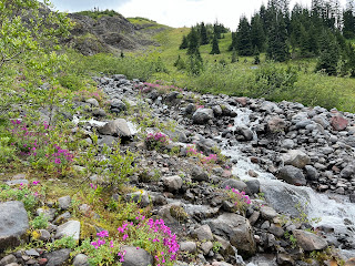
Paintbrush
A larger creek crossing.
Heading to yet another creek crossing. These last two crossing were the largest and fastest flowing. My husband did a great job of finding safe places to cross. We didn't care if our feet got wet so we didn't rock hop, we just plunged in and walked across them.
After making our way up to the ridge we finally got our closer up views of Coleman Glacier.
Heading back down after our lunch break on the ridge. More sweeping views.
Waterfalls were plentiful.
Monkey flowers
Back to our crossings.
My husband and our adventure dog "Scoutina".
Finally found a heart rock on the trail.
I always have to stop and admire the big old trees.
The view of the backside of that same tree. It had grown over a log which had rotted away. This open gap wasn't visible on the other side of the tree.
We stopped on our way down to sit for a bit and Scoutina found just the perfect stick to chew on.
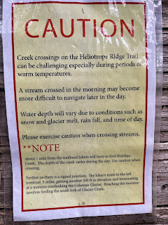
Creek crossing warning sign at the trailhead.
Loved the colors on the bushes at the parking lot.
As we were beginning our drive out we were treated to this view💓
Trail rating: Moderate, but I would assess it as Moderate/Hard
Total miles hiked: 6.3 miles
Total ascent: 1686 feet


