Zoom in on the trail description to read about the trail.
We started out walking along the lake shore and turned at the trail junction going up towards the stairs. Last year we hiked it in the opposite direction by finishing going down the stairs and walking along the lake shore. You can read about that hike HERE.
My husband counted 288 steps the last time we hiked the loop.
We made our way to the first viewpoint. There was a cold breeze blowing towards us as we ate part of our lunch at the viewpoint.
While we ate our beast Scoutina enjoyed a stick.
A face in the forest. I see two eyes and a mouth.
We made it to the terminus and stopped to eat the other half of our lunch. It was chilly. We could see the breath from our dog and the steam coming out of my thermos of Beef broth.
Our usual lunch spot.
We made our way down the trail by quick walking and jogging until we got to the second viewpoint. As we made our way down in elevation it got much warmer. We sat and enjoyed not only the view but the sun's warmth.
I took fewer photos this time around and my Garmin actually got the same distance given at the trail signs. I only saw 2 Trillium on this hike, thought I'd see more.
Total miles: 11
Total ascent: 2350
We had the trail mostly to ourselves for the whole hike.
Yesterday we drove to Anacortes to hike. We started and finished at Heart lake.
I've had distances all over the place for this route from the Garmin watches I've had through the years. This is our 4th time hiking this route and the distances have been anywhere from 7 - 10 1/2 miles and between 1369 and 1877 for ascent. I've noticed that when we hike in rock cliff areas that my Garmin tracking goes off. I have had this happen on the Hertz trail and the Interurban trail. I also get more distance if I stop often and leave my tracking on while we are stopping for a long period of time, it seems to be pinging around me. I try to pause or resume later if we stop, but I don't always remember. So if we average the different times we've done this hike we'd come up with these numbers:
8.5 to 9 miles and around 1600 feet ascent.
I was on the Trillium hunt, but never saw one. I did however see:
Big Leaf Maple flowers
Calypso Orchid
Skunk cabbage in bloom
Baby Ferns
Fawn Lilies
Currant blossoms
Scotchbroom
We hiked around Heart lake on trails #212 & 210
We then crossed Heart lake road and joined trail #247. I love the first section of this trail because it usually has water dripping over the rocks. I took a video that you can watch here: https://youtube.com/shorts/c18eL84H6jQ?feature=shared
While still on trail #247 the trail goes beside some climbing routes. The photo below shows some chains attached to the rock as well as a heart shaped hole in the rock. There are a few small climber trails along the route but stay on trail #247.
There are a couple of benches on the trail, the first one has a ever disappearing view of Lake Erie. The tress keep getting taller.
We then hiked on upward past the second bench and to the next viewpoint. Our dog Scoutina enjoyed the view of Campbell lake.
After enjoying the view we hiked down and joined trail #22, it climbs to reach the junction of trail #21.
We stayed on trail #21until we came to trail #313. We hiked on #313 for just a short distance before crossing the road to the Heart Lake parking lot. I walked down to the lake to get a photo of Mt. Erie in the distance. I always like to look back at where we'd been. Such a nice day on the trail.
I created a screenshot from a map on Gaia (https://www.gaiagps.com/). I put red dots on our route. If you enlarge it you'll also see the trail numbers.
I hope I added enough info. on this post to help you to follow our route.
If you do hike it let me know if you like it as much as we do.
Our first hike in March was a windy and wet journey. March 4th we headed out with our rain gear and hopes for better weather than predicted. We hiked the Burnout loop after driving up the Hiline road, to the Cleator road trailhead and parking at the Cyrus Gates Overlook. There wasn't much of a view with the grey clouds.
**Click on the collages to zoom in on the photos.
We headed down the Rock trail with our beast Scoutina. She's figuring out how to go slowly down stairs etc. on leash and not knocking down my husband.
We walked past the unique rock formations beside the trail.
It had begun raining so we put on our rain gear. It was quite windy on top, so we didn't stay up there long. There were reasonable views from the top of Burnout. There wasn't even a view of Lake Samish or the mountains at the easterly summit viewpoint. We ate lunch here but it soon became cold so we packed up and left.
We took the Lost lake trail towards Fragrance lake, by the time we got to the Cleator road it was pouring rain. It was a short distance from the Fragrance lake trailhead to the Cyrus gates overlook parking lot, so we didn't suffer in the slog too long.
Total distance: 6 miles
Total ascent: 1518 feet
March 6th gave us better weather for our hike on the Tursi trail at Fidalgo Island. I did a screenshot of the brochure put out by the Skagit county parks and rec. it highlights the historic areas of the trail. Zoom in to read about the old mine etc.
The short walk on Donnell road to the trailhead gives a nice view of Mt. Erie and Lake Campbell.
I always enjoy when we get to the old mine entrance and the cabin remains. The trail had a couple of obstacles for us but nothing too daunting.
Glimpses of spring were apparent along the trail. We ate at the old house site. We had a leisurely lunch soaking up the warmth from the sun.
Our loop included walking past the Big Cedar tree. On our return walk to where we parked the car we were treated to another blue sky view of Mt. Erie.
Total distance: 6.13 miles
Total ascent: 1453 feet
March 11th found us on Whidbey Island and hiking Goose rock. We saw more signs of spring along the way on this hike. An early green leaf and skunk cabbage sighting.
We hiked under the Deception pass highway by way of the Discovery trail. We headed up the back side Goose rock through the Rhododendrons. They weren't close to budding yet, but I suspect it won't be long.
I put two photos together to try to give an idea of the view from the top. It was windy and a bit chilly on top for our lunch. Scoutina graciously posed for my while we were eating. We headed back down by way of the perimeter trail and enjoyed our views of Cornet bay and the Deception pass bridge as we worked our way around.
Total distance: 6.65 miles
Total ascent: 1145 feet
March 14th we were invited by our son and his fiancée to hike up Elk mountain. The weather was supposed to be iffy with some lowland snow predicted. I didn't know how I felt about hiking up the mountain if it snowed. We were told it was a fairly short hike but steep. We had already planned on bringing microspikes so when we arrived in Chilliwack B.C. for the hike I wasn't surprised when our son said let's go, we're hiking up in the snow.
Our son was right the trail got steep, so we stopped to put on our microspikes. They helped immensely. That last section quite the grind but with some rest stops and encouragements, I made it to the viewpoint. What a beautiful day. The clouds were moving around but we managed to get some great views of the valley below.
The first downhill section going back down was a bit out of my comfort level, but again with breaks and encouragement I made it through that bit. Instead of following the complete trail back we joined a logging road for the return of the lower section. It turned out to be a great choice, we had some amazing views.
Here's a screenshot from the Peakfinder app of the mountains we were seeing to the south.
My Strava AI report agreed that the hike was a bit more challenging than I'd been doing this year.
Total distance: 5.68 miles
Total ascent: 2292 feet
I knew the Daffodils were getting in full bloom so we headed to Skagit Valley on the 22nd to check them out. Sure enough several fields were in their glory.
March 25th was supposed to bring us some warmer weather than usual, so we headed to Ebey Landing to hike near the water. It was interesting going across the Deception pass bridge because it was surrounded in fog. We didn't expect our views to be hidden in fog but sure enough there was a fog bank out along the ocean. It didn't show up in my photos, but Mount Rainier to the south was peeking out above the fog. We were above the fog on the bluff trail, but walked in it on the beach. I've never hiked at Ebey with so much fog and it gave a nice eerie feel as we walked along the beach. Without the usual landmarks I was quite lost and had no idea of how close we were to the lower State park parking lot until we were suddenly there. Again as we made our way up the bluff to where we'd parked we hiked out of the fog and into the warmth of the day.
Total distance: 6.16 miles
Total ascent: 465
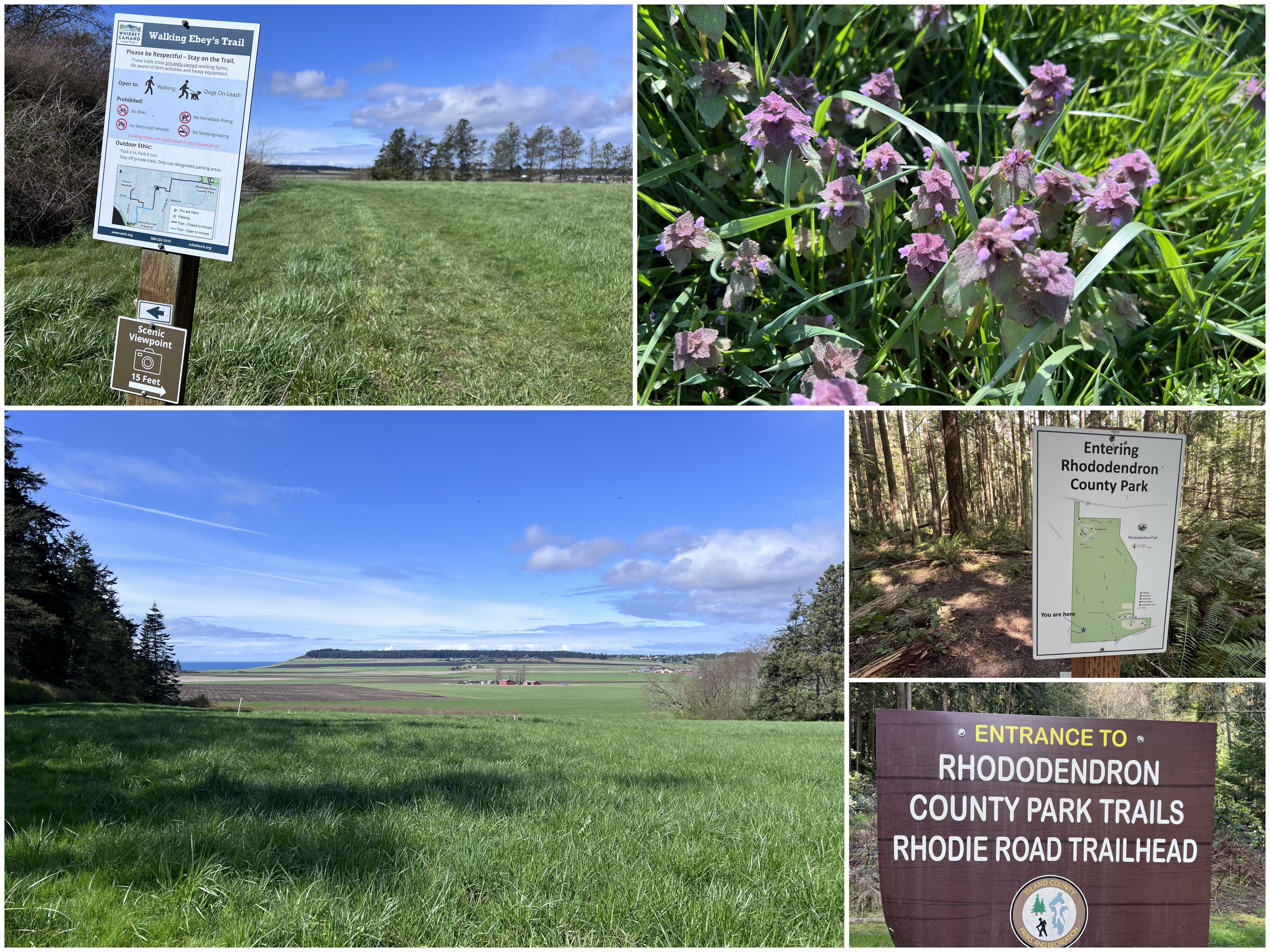
Near the end of the month, my husband chose a hike on Whidbey Island for his birthday activity. We went to the Ebey trail system parking lot and hiked to the Rhododendron forest and back. It's a favorite of ours. It seems we go through several ecosystems on this single trail, so it's very interesting as well as scenic. No rhododendron were in bloom yet but that didn't stop us from enjoying that forest as well.
There was a high water section on the trail that had barbwire fenced cow pasture land on both sides of it, we tried to find a way around the water but weren't successful. The cows found our dog to be highly entertaining. They excitedly followed her as we made our way back and forth looking for openings in the hedging. There was nothing to do but walk through it or turn around. I wasn't for turning around just for a little water so onward we went.
Just before the downhill slope that leads to the road crossing we spied a sign for a scenic viewpoint. I'm glad we noticed it as we turned the corner we had a nice view of the bluff area of Ebey that we'd just been to a few days before. After hiking to the Rhododendron county park, we kept walking to the campground and ate at a picnic table for lunch. Here's a link to info. for the campground and park (https://whidbeycamanoislands.com/activities/rhododendron-park/).
As we made our way back we got to cross the water again. It got to about our knees, it felt nice and cool. My husband contained the beast so she wouldn't run off with him. After the short forest walk near the parking lot we were done. It was an excellent destination for the special day.