Monday, September 14, 2015

Rainier Vacation - Part 4 Shadow lake loop

Day 4
Part 4 of our Rainier camping & hiking vacation.
If you'd like to catch up with our Rainier vacation you can read -
 Part 1 our camp at White River campground HERE 
 Part 2 Owyhigh lakes hike HERE
 Part 3 Shadow lake loop hike HERE. 

Again our spirits were buoyed by a glorious blue sky when we woke and a great view of Rainier from our. White River campground campsite.

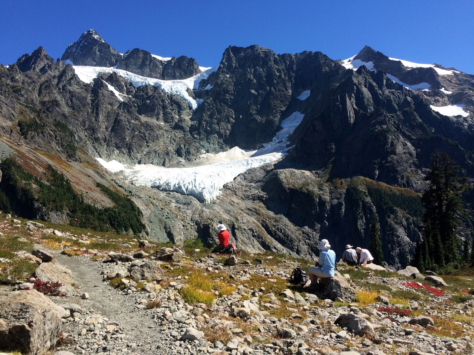
We decided to drive up to the Sunrise visitor center parking lot and hike around Shadow lake.Shadow lake. We stopped at a tourist pullout to read about the Columnar Andesite along the road.

We also stopped at Sunrise point to check out the views. It overlooks the Palisades lake trail. This is one we would like to do on another trip. When we looked up at the hill in front of us, we saw lots of white dots so we got out our binoculars and sure enough they were mountain goats.
Sunrise lake
If you zoom in to enlarge the photo below you will see many mountain goats on this hillside.

When we got to the parking lot, we noticed there was a dusting of snow. It was a bit chilly but not too bad. We put extra layers to wear in our day packs and headed to the visitor center.

Flowers in the snow.

Examining the wonderful 3-D map of Rainier and it's trails.

Our hike to Emmons Moraine in my Part 3 post overlooked the lake in this visitor center display. I learned more about "Kettles" here.

Off to the Shadow lake loop.


A couple of deer along the service road.


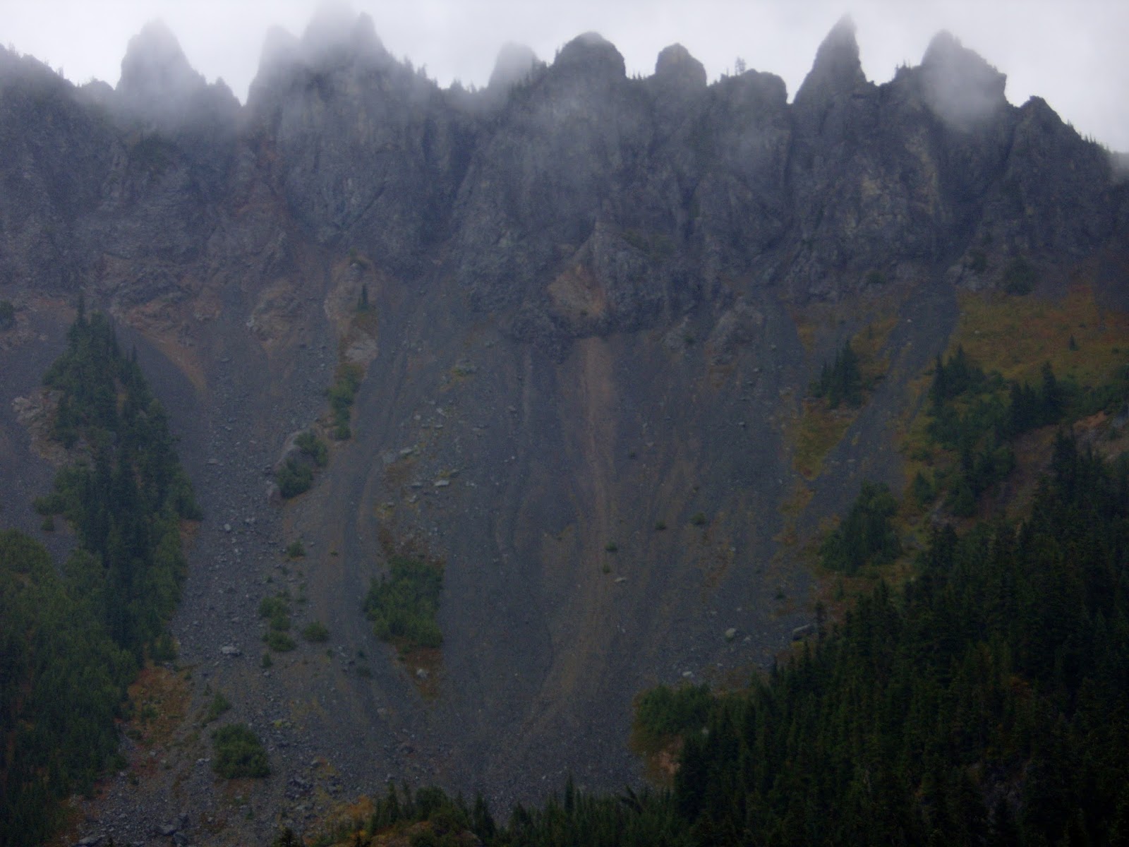
A light rain began to fall and we heard a thunder roll in the distance.


The light rain turned to sleet and then snow.


Check out the before and after pictures of the parking lot from our day. When we returned to the parking lot it was a different world. We began calling this week the "time that July turned into October". After our hot summer, we really didn't expect this. Soo glad we brought clothing for whatever weather we might have.


Total miles hiked - 2.5 miles
Maximum altitude - 6400 feet

Sunday, September 13, 2015

Mount Rainier Vacation Part 3 - Emmons Glacier & Glacier Basin

Day 3
Part 3 of our Rainier camping & hiking vacation. 
If you'd like to catch up with our Rainier vacation trip you can read about -
Part 1 our camp at White River HERE
Part 2 Owyhigh Lakes hike HERE.

The day dawned with a wonderful blue sky, I walked around the campground loop to get some pictures. This is the hill just across the river and behind us.

I looked up towards Mt. Rainier and sure enough I could see Emmons Glacier and a bit of Rainier.

We decided to hike the Emmons Moraine trail and then continue up the Glacier Basin trail.


Heading across the "prepared log" :-) bridge towards the Moraine. 
If you read the Part 1 Owyhigh post you'll see why I added a winky face.

We learned about "Kettles" at the Sunrise Visitor center. The lake below is a Kettle. A kettle is where a large block of glacier broke free and melted to form a lake.

Looking at the base of Emmons Glacier.


It was such a nice warm section to hike, the sun felt sooo good while we stopped for a lunch break.

Then on to the Glacier Basin trail. The clouds moved in and it started raining shortly after we got back at the trail junction that led on up to the basin.

I appreciated the log steps going up to the camp.

When we arrived at the camp, there was bear activity information posted. These signs are usually posted in the back country,


We walked out into the opening of the basin, hoping for some views, but visibility was not so good We could see the ridge that led to Camp Schurman, but that was about it. It was beginning to sleet and get cold, so we headed back.

Dinner at a soggy campsite.

Thank goodness, he brought umbrella's. Little did we know how handy they would be.

Total miles hiked - 8 miles
Total ascent - 2100 feet
Maximum altitude - 5,800 feet

Friday, September 11, 2015

Mount Rainier Vacation Part 2 - Owyhigh lakes

Day 2
We had many wonderful (wet & chilly) days on this vacation. I'm sharing each day in separate posts. Part 1 was our camp at White River, you can read about it HERE.
We had several hike ideas selected before we left home. If the weather cooperated we were hoping to include a night or two of backpacking. Since it was cold and wet most of each of our days there, we just decided to stay at our campsite and "weather" through our day hikes :-)
We woke to rain for our first hike of the trip, so we chose Owyhigh Lakes for the day. We packed our day packs with our lunch and got all of our rain gear on and drove a short distance to the trail head.

The trail can also be hiked as a point to point with a long car shuttle. We chose the out and back route since we only had the one car.

  The guidebook we used for our selection of hikes was the Falcon Guide "Hiking Mount Rainier National Park" by Heidi Schneider and Mary Skjelset. I liked the description it gave of this little footbridge in the book. "A prepared log stretching across Tamanos creek marks the end of the ascent". I don't think I've ever heard of a log bridge referred to as a prepared log!

The clouds were just high enough to give us short views of what was around us.

Owyhigh lakes


Governors ridge/Cowlitz chimneys

We strolled on a bit farther on the trail past the lakes and turned around where the trail began it's descent.

We did manage to catch a quick view of some blue in the sky.

Back down the switchbacks to the car.

I would highly recommend this hike if you are in the area. Especially on a rainy day. The hike up in the forest was beautiful and the trees offered some protection from the rain. We found that even on a seemingly dismal day we could enjoy a good forest hike with some views.
We hiked about 7.5 miles to about 5,400 feet with a 1700 feet ascent.

Thursday, September 10, 2015

Lake Ann Trailblazer hike

A wonderful and very warm hiking day for us Senior Trailblazers for our hike to Lake Ann.
Usually in the mountains we hike up at the start of our hikes and then the return trip to our cars is a welcome "up". This hike starts with a downhill through the forest, through a lovely opening with a few creek crossings and then up again to the lake. Then since it's an out and back trail, we reverse everything...hike down, enjoy the lovely opening and creek crossings and then finish with a nice shady forest "up" back to the cars. It was a long hike and a couple of our group stopped at about the 1/2 way point and said they would return to the cars and wait for us, another stopped short of the rocky area and headed back as well. The rest of us rallied on to the top for lunch before returning.
The scenery was in a word "glorious".


I thought the flowers below that had gone to seed looked very magical.


Mt. Baker in the distance


Lake Ann
Thanks to Leslie for getting this shot of me in front of Shuksan.

A perfect place for lunch, what a view.

I'm guessing it snowed here recently as all of the grass is flattened as if by a weight.


After a head count to make sure that we had all returned intact to the cars, we made our way to Graham's for the coveted ice cream at the end of our long day's hike.
Bliss!

Endomondo stats:
Total miles hiked - 8.7 miles
Minimum altitude - 3908 feet 
Maximum altitude - 4849 feet
Total ascent - 1853 feet
Total descent - 1852