Monday, September 2, 2019

Wonderland trail 2019 Day six Golden lakes camp to Klapatche park camp

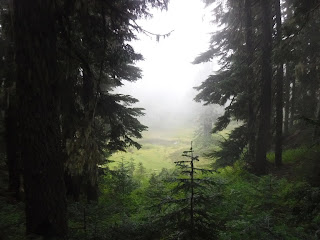
The next day dawned pretty much the same as it had last year at Golden lakes. Foggy and damp. Not really raining this year but very dewy.

No great views either.


At the Patrol cabin.


We entered the Silver forest and continued walking in the fog. Many trees have grown since the first time we were here in 1975, at that time it was mostly just "silver looking" old bleached snags from a past fire that were on this ridge. That and many blueberry bushes, all has changed now


The trail began to descend into a green forest trail.

Another bridge still in disrepair.

After crossing the north Puyallup river and bridge it was time to begin our climb up to Klapatche park.


I loved this large root above the trail.


Heart Rock on the trail.

Last year this section of the trail was horrible, made worse by the hard rain that fell on us all the way to camp. This year we were excited to see some actual trail maintenance along the side of the trail.

A waterfall flowing down the hillside across the way from us.

The trimmed trail didn't last long, we were soon in thick vegetation just like last year. The trail is fairly steep and narrow in this section so not being able to see the trail and where our feet are was a bit unnerving at times.


Some flowers were in bloom, but hard to see with the fog.

We made it to Klapatche park and could barely make out Aurora lake, it was so foggy.

Happily for us it wasn't raining or too cold at Klapatche park this year. The lake had more water in it and wasn't orange as it was last year. I felt much better about drinking it this year. We always filter and boil our cooking water, so we're fine but last year it just looked horrible.

Relive video of our route:

Garmin stats:
9.32 miles
2444 feet ascent
1883 feet descent
Elevation profile:

Trip summary:
49.68 - miles
13,215 feet - ascent
12,291 feet - descent
Elevation profile:


Sunday, September 1, 2019

Wonderland trail 2019 Day five Mowich lake camp to Golden lakes camp

We woke to a very wet tent rainfly. It was the heaviest dew we've had on the tent. We had so much dew because we didn't camp under trees. By the time the sun came up it was shining on the Mowich lake road and parking area. We moved our rainfly to the fenced garbage area and hung it over the fence. It was a good idea because it took the sun a long time to make it to our area. By the time we left everything was dry. No pictures of the drying process, but a group from Tahoe (four women and one man)  thought our idea was great and they did the same thing. Wet items get really heavy in a backpack, so we were all glad to pack them away dry. Time to head to Golden lakes.


We stopped for a rest/snack break on this perfect natural rock bench.

Today's hike had some river crossing and deep green forest views.


The river at South Mowich, can't decide which channel is to be it's main one. It spreads out over a large area. The trail is marked with tape and cairns.


Past the river we now begin a long uphill hike to Golden lakes.


When we got to where the trail veers right and levels out we found the blueberries were ripe. We helped ourselves to their yumminess.


It started getting a little chilly as we made our way to camp in the fog.

The bridges didn't look any different than last year. So sad, it would be nice if Rainier would allow volunteer crews to come in and do trail/bridge repairs.


The first lakes come into view (kindof).


Finally at the Patrol cabin.

We found a nice site and put up our tarp in case the clouds and fog brought in rain overnight.

The clouds parted long enough for me to get a photo of the lake below. This was the view from the ridge where our tent site was located.

Relive video of our route:
https://youtu.be/tMhCM_PUO14

Garmin stats:
11.53 miles
2510 ascent
2539 descent
Elevation profile:

Trip summary:
40.36 - miles
10,771 feet - ascent
10,408 feet - descent
Elevation profile: