Saturday, February 1, 2020
Thursday, January 30, 2020
Alger Alp/PNT exploration hike
Today our hike started at the Squires Lake Park parking lot.
We walked uphill a short ways until we got to the lake. There was some wind carnage (fallen trees) here and there along the trail.
At the lake loop trail junction sign post, there are Blazes for the Pacific Northwest Trail or PNT. Today my husband wanted to see where the Blazes were for the PNT as we made our way up to Alger Alp.
I walked out to where the bridge is in the above photo. I wanted to see how the lake looked before we began. A wee bit of fog, but still a nice reflection.
We turned right from the lake trail junction sign and hiked to the South Ridge trail. I love this trail because it follows the spine of the ridge for a short ways.
A nice Woodpecker hole.
Another PNT Blaze before a view bench.
Here's the impressive view from the bench.
Back on the Ridge trail another Blaze and an actual emblem marker posted on the tree. The Pacific Northwest trail is part of the National Scenic trails.
As we made our way along the Spine my husband got to do some trail maintenance today. There were a few small trees across the trail in this section. He had another chance to use his trusty hand saw.
Our first "real" view from the trail, looking towards Blanchard mtn.
As we made our way farther on the trail, it eventually became an old logging road that wound around to the other side of the ridge. We went off on a spur (dead end) trail and climbed up to a rocky area to get our first view of Mt. Baker.
This (photo) view of Mt. Baker with the Twin Sisters was taken from the road shortly before we reached the topmost part of our hike.
When we got to the top we found a nice rock to sit on for our lunch break. The sun was shining off and on through the clouds while we ate. After we got home I was surprised to see that I had a slight sunburn on my face.
Our lunch view looking south to Skagit county,
Our view west looking past I-5 and way out to the San Juan Islands and the Olympic mountains.
I tried a zoom view with my small camera. In the photo below the Islands are more clear than the Olympics, and in the second photo you can see the snow capped mountains a bit more.
On our way back down from the top we turned to follow the Blazes to where the PNT heads towards Alger. We walked on this logging road for a ways and were able to look up and see the top of the Alger Alp and where we had just come from.
After our short walk on that section of the PNT we headed back to the "Spine" South Ridge trail.
Looking back at the Spine.
As we made our way down the South Ridge trail there were some obstacles in our path. We then came to where the trail intersects with the Squire lake loop trail.
We both got to do some water diversion work on the Squire lake loop trail. Hurray! No photos of our work this time though.
Before we went around the lake we decided to do the Beaver pond loop.
The Beaver pond
The Beaver Dam
The Beaver Dam from the other side.
Then on to the rest of the Squires lake loop trail.
Turkey Tails on a log.
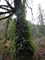
Licorice Fern on a tree.
As we made our way along the the trail we found some rock steps leading to the lake shore, we went down them and to this bench with a memorial plaque beside it.
She sounds like she was a fun person and that those who knew her enjoyed being in her presence.
And best of all, she was a quilter❤.
Her plaque reminds me of what I wrote on the side bar of my blog: "I believe that every person born on this earth is a relevant, impactful presence here. When each of us was born we permanently changed history. We are not a speck that passes unseen. Our very existence leaves a mark, whether it be in a person or just as a footprint on the earths' surface. The earth is different because we exist. We are marked forever in our loved ones and friends souls."
Jill did not pass through this earth unseen, her friends cherished her and now each person that makes their way to this small cove on the shore of the lake are touched by the words on this plaque.
Reflections on the lake.
Looking down the length of the lake towards the small bridge near where we began.
Looking up the lake (from the small bridge) as in my first photo in this blog post, still pretty just minus the fog of our morning start.
It was fun following the PNT Blazes of the Alger Alp area, and we managed to get our full hike in without one drop of rain😊.
Garmin stats:
total miles hiked - 6.5 miles
total ascent - 1440 feet
Map of our route:
Subscribe to:
Comments (Atom)


