Today was a day of walking through wildflowers, old burns and dry open hot ridges.
We began our upward journey.
Mount Rainier peaking over a ridge.
We walked beneath many rock formations. I liked how colorful this one was.
Wildflowers everywhere!
Our first "field" of Lupine. This first sighting of a Lupine field was just gorgeous, and the scent was amazing. Little did we know just how amazing the Lupine would be on this days hike.
The Lupine just kept going. I wish I could have bottled the scent, so light and delicious!
There were a few other flowers mixed in here and there.
As we made our way around to a more exposed area the flowers were thinner but still abundant.
We ate our lunch at Martinson gap. I liked one of the comments in the Guthook app. They called it Mosquito hell. Pretty correct comment. We donned our mosquito head nets and sprayed ourselves with repellent so we could enjoy eating our meal.
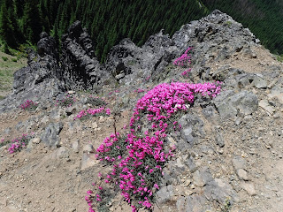
Wildflowers growing out of rocks.
One of our tree obstacles. Over or under. It was a bit too high off the ground for me to climb over. My husband went over, I went under.
Our first trail-side snow.
We appreciated the Guthook app more times than I thought we would. If alone I probable would've taken the Arch rock trail instead of turning right and following the PCT. I whipped out my app and saw that we did need to turn right. We went nearly a mile before we came to the Arch rock spring. The better water source wasn't at the sign marker as shown in the photo below but a few yards down the trail at a campsite in the burn. There was lots of water flowing strong there. The camp was open with lots of burned trees around it, I didn't find it a desirable place to stay, just dirt and burned logs to sit on at the camp. Since it was only mid afternoon, we pressed on.
We had read that there might be Elk frolicking in this section. We listened and looked, but all we saw was a lot of tracks. We were treated to the abundant Lupine again as we walked through this burn.
We walked through this short section of hard packed soil. Our book said that they are geological formations left behind by melting glaciers.
We began our search for a camp, the one place near the Louisiana Saddle area had a tent at it already. So on we went.
As you can see in the photo below, my husband is carrying a water bag. He also had another extra one in his pack. We needed to carry our own water since there were no camps or water spots for a few miles ahead of us. We cook our dehydrated breakfast and dinner meals so water is essential. He did this many more times on this trip, never complaining about the added weight. He did this for many miles, he just kept marching on looking for a suitable site to camp.
Finally! A trail-side space near Rods Gap with our names on it. It couldn't have been more perfect. There was a large log near where I was standing to take this photo, so all the luxuries of life: a place to sit at a reasonable height and a flat place to set up our tent. Ha!
Relive video of our route:
Garmin stats:
miles hiked - 10.32
total ascent - 850 feet
total descent - 2192 feet
to be continued......


No comments:
Post a Comment
Thank you for taking the time to read my blog, I welcome your comments.